The Compleat Works
Beinn nan Aighenan from Victoria Bridge
I should have read the documentation. This was a far harder walk than going in from Poolewe to the Fisherfield hills, and mainly because of what was underfoot. After Clashgour hut, you can take bikes further, but you are by now in the grasslands of the West, and I don't mean the prairies, but a botanic garden of lush, long, tussocky grass, soaking wet from some deluge in the past day. Through this the path wends, a foot wide, sometimes sinking to a waterfilled rut. We also had to do some wading, the Allt Ghabhar bridge having gone. The water was warm.
To be fair there are some miles of good hard track after you cross the Shirra footbridge. Then comes the Kinglass crossing, three hours out from Victoria Bridge. Not having read my notes or the map properly I didn't know there was a new strong bridge downstream at 186402. No sign on this route points walkers to it. The ford we used near the old bridge site was a double one, and six inches more water would have called for a rope. On my own I'd probably have given up at this stage. Then we had lunch and a brew, and wondered about a tattered poly bag, with two pairs of approach shoes in it, left by the track.
Counter-intuitive progress followed, walking away from the summit and down Glen Kinglass. Not having read the notes properly (again) we turned N up the steep hillside about a mile from the ford. Apparently if we'd gone just a bit further there is an 'easy' path up the corrie behind. Much more long grass, and I'm surprised it can grow so well on such steep deer-infested ground. At this stage technology gave us a fright.
R's compass, on the way out, had shown reversed polarity. I got mine out to take a back bearing on a wood by the river, before the cloud came down. Held it out to watch the needle settle. The needle revolved slowly to North, then kept revolving, swaying gently with each move of the wrist. It was all right in Fisherfield! Today, at home, its polarity is reversed too. Maybe it had been next to something nasty on the train. An iPhone gave us a working compass, and I'm ashamed to admit a grid reference: we were just where we wanted, and about half an hour's walk from Beinn nan Aighenan's E ridge. We gained this, and stared along its bumpy, rough, rounded 4 km to a shroud of grey on the summit. We were five-plus hours out now and at least the way was clear. We got to the top at 4.15.
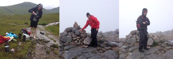
On the way up: lunch in Glen Kinglass, the summit cairn.
Reader, you may be waiting for me to break out the cigars and Cava, because it was my Last Munro. I didn't. First, because we had taken seven hours and I wanted back on the road before dark; second, because this is the narrative of the country's first Secret Munroist. Instead I ordered R to take a photo of me at the cairn: (10/10 cloud, mist, strong wind) and we sought and found a good reliable scar track off the summit, going N and a bit W. We couldn't face those 4 km of up and down on the ridge again.
Hardly 100m down we passed some tiny lochans to the L and suddenly the lochans were blue and the sky was torn white and blue and the rocks were pink. Ben Starav and Glas Bheinn Mor blinked into view, a few seconds at a time. It didn't last, but it was more sun than the previous four visits to the Etive Munros had yielded.
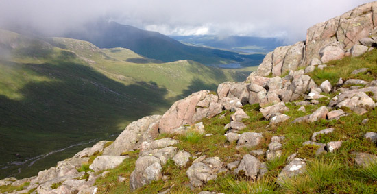
On the way down: Loch Dochard and Loch Tulla in the far distance
And about now we had a break and I said, 'That was the hardest Munro I've ever gone up. And it was the last.' So at least one person knew the secret. Then at the bealach at 618m we turned R and started down a long green grassy glen, Coire na Caime, walking E towards the good track we came out on. More grass, more water. So long, so straight – it took two hours. A little path came and went, meticulous cairning came and went. It was so over the top, this cairning, that I imagined it the work of a school or DoE party, being given something to do by a leader. And then the hard track and the last cups of tea were taken, and we were down to the final 90 minutes, the final minutes in a journey of 37 years.
Through the midges, and cycling faster than I ever had on rough ground, we shot down the glen, over Victoria Bridge, and surprised the crew of a Dutch campervan roosting in the car park. It had been 12 hours almost to the minute. I am not a fast walker. The journey was around 28 km and 1100 m of up and down.
And there was still no Cava and I was a bit too tired to eat; but at the Green Welly garage R devoured something with meat in it and I sooked at a powerful and pungent bottle of ginger beer. Beats coffee any day for keeping drivers awake. And it was past the Real Food cafe with them stacking chairs for the night, and past Crianlarich YH and the thought of a tea and a nip in their dining room; and a stop at lovely scruffy Inverarnan Drover's for more ginger beer, and all the milestones to the city slipped by in a warm, gloomy dusk till we were approaching Anniesland and I took a slip road by mistake; we had a few minutes of non-being in Knightswood before managing to escape. And that was the last mishap of the day.